

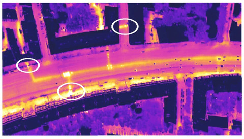
Airborne infrared imaging of urban areas is an effective method for remote, non-destructive inspection of housing and municipal utility infrastructure. JSC GNPP Aerogeofizika offers housing and municipal utility monitoring to diagnose heating networks and other facilities and identify sections of utility infrastructure that are at risk of failure or already in emergency condition.
What the service includes
Housing and municipal utility monitoring covers the complete technological work cycle:
- obtaining flight permits;
- airborne thermal infrared imaging of urban areas;
- production of digital map layers in the client’s automated geographic information systems (GIS) (GIS ZULU and others)
Aerogeofizika monitors housing and municipal utilities in Moscow and in more than 40 other Russian cities. We have worked in this field since 1992, successfully applying airborne thermal infrared imaging to automate diagnosis of heating networks and urban infrastructure. Our clients include municipal utility services, property management companies and utility suppliers.
The principal advantages of airborne thermal imaging are speed, productivity and reliability. The method enables extensive areas to be surveyed in a comparatively short time. The resulting data are highly reliable and can be used in engineering and management decision-making and for record-keeping.
Equipment used
For airborne thermal imaging, we use a thermal imager developed in-house that provides a spatial resolution of 20 cm from an altitude of 350 m. Liquid-nitrogen cooling enables images with the highest temperature contrast to be obtained even at high survey speeds.
The thermal imager can be installed on different types of aircraft:
- helicopters;
- ultralight aircraft;
- uncrewed aircraft.
Airborne thermal infrared imaging is carried out under the following weather conditions: air temperature ± 5°C, no precipitation, wind speed up to 10 m/s, and complete cloud cover above the survey altitude.
Flights can be conducted by day or night using satellite navigation system data (GPS-GLONASS). Housing and municipal utility monitoring can be commissioned at any required frequency, including on an urgent basis.
Tasks that airborne thermal imaging can address
Airborne infrared imaging provides the most comprehensive possible characterisation of heating network condition with minimal financial and time expenditure. The method is used to address a wide range of tasks:
- detection of heat leaks and damage to heating pipelines;
- monitoring changes in heating network condition over time;
- updating maps of underground and above-ground heating networks, chambers and buildings in the city.
Preliminary data are delivered to the client on the day after the survey. Rapid diagnostic data enable the precise location of heating network damage and sections requiring immediate attention to be identified at once.
Remote monitoring of heating networks identifies sections with increasing heat losses. Commissioning this service enables heating networks showing a tendency towards deterioration to be detected. This makes it possible to predict the development of emergencies and prevent serious consequences.
The price of housing and municipal utility monitoring is determined individually on the basis of approved rates. The cost depends on the equipment and transport used and on the volume, complexity and urgency of the work.
Airborne thermal infrared imaging can be carried out simultaneously with airborne laser scanning. This enables the client to receive a digital model of the city’s surface and terrain (as a point cloud or in vector or raster formats following additional processing).