Hydrocarbon exploration
Oil and gas companies are conducting exploration in increasingly challenging regions in terms of geology, climate and infrastructure. The high mobility and relatively low cost of airborne geophysical surveys can substantially reduce the time and expense of exploration supporting hydrocarbon exploration and production, while minimising environmental disturbance.
JSC GNPP Aerogeofizika has extensive experience in airborne geophysical surveys commissioned both by subsoil licence holders and by the Ministry of Natural Resources and Environment of the Russian Federation.
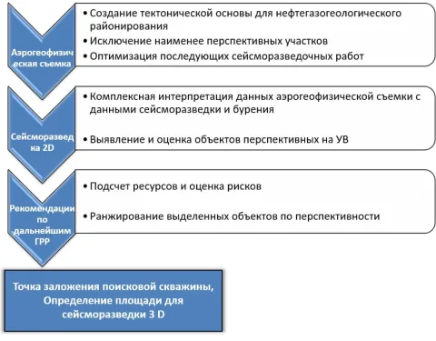
Airborne geophysical methods are most valuable during the regional and prospecting stages of exploration. At the appraisal stage, integration with seismic and drilling data provides substantial additional information, helping refine the geological model, reduce geological uncertainty and improve estimates of hydrocarbon resources.
Airborne geophysical methods and technologies are currently used to investigate areas prospective for oil and gas, to prepare and monitor exploration operations, and for environmental observation and pipeline monitoring.
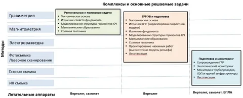
With the growing choice of aircraft platforms and improvements in instrumentation, airborne geophysical services for hydrocarbon exploration can be grouped into three principal categories.
The first, historically established category comprises gravimetry and magnetometry. It addresses regional and prospecting objectives, particularly when an operating company gains access to a licence area, evaluates its exploration strategy and begins searching for hydrocarbon deposits.
The second category adds airborne electromagnetic surveying, aerial photography and laser scanning to airborne gravity surveying and magnetic surveying. It addresses regional and prospecting objectives and supports preparation for ground exploration. This category requires a helicopter platform.
The third category supports preparation and monitoring of oil and gas exploration operations. The methods used allow ultralight aircraft and UAVs to serve as survey platforms.
Exploration of hydrocarbon deposits
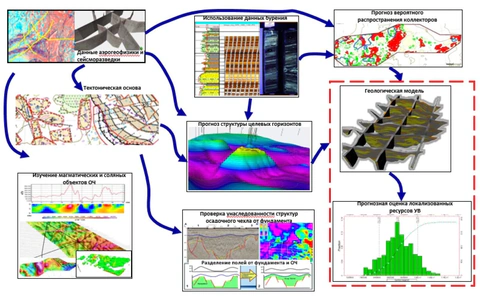
Airborne geophysical data processing and interpretation algorithms have now been substantially improved. New algorithms for exploration applications draw on experience accumulated in Russian airborne geophysical surveying and by international oil and gas and airborne geophysical companies. Interpretation focuses primarily on integrating and jointly analysing potential-field data with ground electromagnetic, seismic and drilling data. Data processing and interpretation require an approach tailored to each region rather than a uniform procedure. This approach provides an individually optimised solution to a complex problem, taking account of project-specific conditions, and has proved highly effective.
In the oil industry, integrated interpretation results are used to construct and refine geological models. These models, in turn, support quantitative assessment of hydrocarbon volumes and the definition of subsequent exploration strategies.
To optimise exploration schedules and costs, we always aim to complete survey operations within a single field season, regardless of survey area or scale. If there is a risk that fieldwork may extend into a second season, planning considers the deployment of additional aircraft and instrument sets, including UAV-based magnetic surveying.
Airborne geophysical surveys for hydrocarbon exploration can rapidly acquire large datasets without environmental disturbance. These data help refine understanding of the geological structure and hydrocarbon potential of the study area, enabling subsequent, more costly seismic and drilling operations for oil and gas exploration to focus on the most prospective areas.