

Home · Resources · Presentations
GeoWebinars’21. Use of UAVs and ultralight aircraft for high-resolution airborne geophysical surveys.
Alexey Andreevich Trusov1, Pavel Surenovich Babayants1,
Oleg Rafailovich Kontarovich1
1 JSC GNPP Aerogeofizika
Introduction
Mining companies and entrepreneurs in the raw-materials business continually face the need to assess the prospectivity of licence areas rapidly in order to optimise mining and drilling operations while increasing their effectiveness. Licence-agreement requirements often impose very tight deadlines on geological investigation of an area. Under these conditions, inexpensive and mobile airborne geophysical technologies are virtually the only option, allowing large areas to be surveyed in the shortest possible time without any anthropogenic disturbance of the area studied. Their effective use is supported by rapid development of both the instrumentation and technical base and the technologies for processing and interpreting data.
In recent years, a branch of airborne geophysics involving uncrewed aerial vehicles (UAVs) and ultralight crewed platforms has been developing rapidly, making it possible in most cases to reduce the cost of rapid assessments of the prospects of licensed areas. However, each of these platform types has its strengths and weaknesses.
Advantages and limitations of surveys using UAVs and ultralight crewed platforms
Multirotor and fixed-wing UAVs are widely used today, whereas vertical take-off and landing systems (such as tiltrotors) are less common. Electrically powered platforms are becoming widespread because they are easy to operate; however, UAVs with internal combustion engines (ICEs) or hybrid power systems offer substantially longer flight endurance.
Currently used UAVs with take-off weights of up to 30 kg impose stringent limitations on payload weight and, consequently, on the range of geophysical instruments that can be installed.
In recent years, the development of ultralight crewed aircraft has created additional opportunities for detailed airborne geophysical surveys. Their use is not subject to the same stringent constraints as UAVs; they have much greater payload capacity and power availability, yet do not require dedicated runways, are easily transported to the work site, and have good flight performance.
One example is a light aircraft currently available for use that, when folded, fits into a trailer towed by a passenger car (Fig. 1), can fly for up to 6 hours without refuelling at a speed of 100 km/h, and can conduct low-altitude surveys.
Ultralight crewed aircraft are comparable to uncrewed platforms with ICEs in terms of permissible flight altitude, speed and endurance. However, they have a higher rate of climb, allowing their use in hilly and weakly dissected terrain. Their most important advantage, however, is their payload capacity, which permits the installation of an entire suite of geophysical methods—that is, a set of geophysical instruments capable of obtaining information on different rock properties in a single pass.
The ability to take measurements at extremely low altitudes and to follow the terrain in great detail, maintaining a constant sensor height above the ground, is cited as an important advantage of surveys with light UAVs. Aeromagnetic surveys at the lowest possible altitudes do indeed bring their results as close as possible to ground survey data, thereby eliminating the possibility of missing weak magnetic anomalies. However, in many cases the influence of near-surface magnetic formations (such as moraine deposits) is simply detrimental, masking and distorting anomalies from target objects. Flying at a greater altitude can substantially reduce their influence.
Thus, the optimum flight altitude should be selected deliberately, taking into account the geological structure of the area and the characteristics of the target object. It should also be noted that, however desirable it may be, flying below the tops of trees in the survey area is impossible, and these are often 25–30 m high.
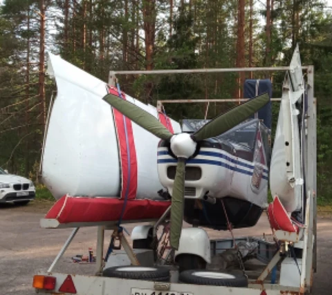
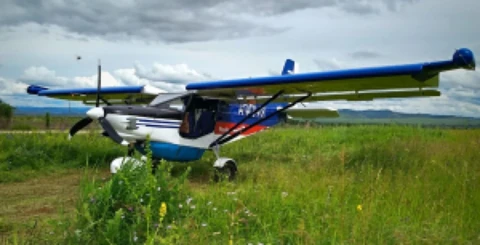
Fig. 1. Light aircraft: а – folded for transport on a car trailer; б – in operational configuration.
Available airborne geophysical methods
Magnetic surveying is the simplest and most accessible geophysical method. Quantum sensors manufactured both abroad and domestically are used to obtain high-quality data. Their modern versions retain the same high sensitivity while being more compact and lighter. Various instrumental and technical arrangements are now used to conduct such surveys with all types of platforms (aircraft, helicopters and multirotor UAVs) (Fig. 2).
Given the technical characteristics of UAVs (limited payload capacity and low power availability), the adaptation of gamma-ray spectrometry to drone surveys is based on gamma-ray detectors that are substantially smaller than those used in conventional airborne gamma-ray spectrometry. The reduction in count rates associated with small detector volumes is partially offset by lower observation altitudes and reduced flight speeds, including hovering measurements. UAVs most commonly use detectors with volumes of 0.4–0.6 L, whereas light aircraft can carry units with crystal volumes of 16 L. The limited statistical representativeness of data obtained with small-volume detectors (0.4 L) necessitates averaging measurements along the flight line, substantially reducing the detail of the resulting models of natural radionuclide concentrations. Surveys involving hovering with multirotor platforms clearly reduce productivity sharply.

Fig. 2. Magnetometry using a multirotor UAV
Self-contained airborne electromagnetic systems (without ground installations) are currently limited to passive methods—a variant of VLF, known in Russia as radiokip or SDVR. Navigation and broadcast very-low-frequency radio transmitters serve as sources. Modern implementations of this method are sufficiently compact to permit use on UAVs of any type as well as on crewed aircraft. In most cases, this method can delineate near-surface tectonic zones.
In our view, the most promising approaches involve placing a closed-loop or linear field source on the ground surface and measuring components of the secondary field from the air. This arrangement can implement the transient electromagnetic method and the low-frequency inductive electromagnetic techniques that have been unjustly neglected in recent years (the ungrounded-loop and infinitely long cable methods), including measurements outside the loop.
The advent of a new generation of compact strapdown gravimeters has made airborne gravimetry possible using ultralight aircraft and helicopters. Since a distinguishing feature of this class of instruments is their ability to remain operational under large vertical accelerations, they enable closer terrain following and simultaneous airborne gamma-ray spectrometry and magnetometry. The resulting gravity-field models help map intrusive complexes, fault structures and block structures.
Supplementary aerial photography provides orthophoto maps that can be used to plan prospecting traverses, design ground geophysical and geochemical surveys, and interpret geological features. In addition, photogrammetric algorithms have been developing rapidly in recent years, enabling the construction of reasonably accurate terrain models.
Conclusion
The suite of airborne geophysical methods must be selected according to its effectiveness in addressing the specified geological exploration objective. At the same time, currently available ultralight aircraft have a number of characteristics and limitations that must be considered when designing airborne geophysical surveys. Selection of the optimum platform should be determined not only by the chosen suite of methods but also by the specific geomorphological conditions and the size of the survey area.