

Home · Resources · Publications
Airborne geophysical technologies serving the capital
| Author(s): R. S. Kontarovich, S. A. Sklovsky, A. V. Davydov |
Who among us has not, at least once, watched a low-flying helicopter and wondered: “Why are they flying around over Moscow like that? And, most importantly, who is paying?” Apparently, similar thoughts have occurred more than once to responsible officials in the Moscow government, who have imposed exceptionally strict rules for flights over the city. As a result, many operators stopped flying. Not all, of course: Aerogeofizika, for example, still regularly flies over the city, which speaks for itself—they must be doing useful work if they are allowed in. Our story is precisely about the benefits of aerial surveys for the capital, not merely their harmlessness but their genuinely high economic effectiveness.
Today, meaningful oversight of the environment and municipal infrastructure in a metropolis such as Moscow is hardly possible without monitoring, understood as a set of measures for regular surveys, assessment and forecasting of conditions across the capital.
Three main types of environmental monitoring systems are currently developing worldwide:
- systems based on permanent integrated monitoring stations, currently adopted in the West and, in our view, extremely costly, particularly when funding is allocated on a residual basis, because they require a dense network of expensive sensors, a data-transmission system and a single powerful processing centre;
- a network of integrated mobile ground laboratories, used in Russia and the CIS countries, which essentially permits only selective monitoring, both in the range of pollutants and in the area covered;
- remote monitoring based on integrated aerial surveys, which provides information for extensive areas in a short time but cannot detect emergencies.
If you ask any environmental specialist how, in their view, an environmental monitoring system for the air of a city such as Moscow should best be organized, you will hear approximately the following reasoning: one integrated fixed station should be installed per square kilometre (somewhere at ninth-floor level), recording 20–60 parameters that constitute the core list of principal pollutants; information should be collected (for example, via modem) by a network of 10–15 computers; and data processing should be organized. This would enable the dynamics of processes occurring in the atmosphere of such a large industrial centre to be tracked, their relationships with meteorological parameters to be established, and predictive models to be developed… However, it should be borne in mind that the city covers approximately 1200 km2, while one such station costs around 350–500 thousand dollars. Multiplying these figures shows that the most effective monitoring system is, broadly speaking, beyond our means. This is environmental protection for the wealthy… Industrially developed countries do, however, follow precisely this approach. Admittedly, they have different mechanisms for obtaining funds for environmental protection…
Surprisingly, there is another way to obtain integrated information at a level of detail exceeding even that described above. Indeed, if we cannot afford to deploy 1200 stations, perhaps we could assemble at least one, mount it on a helicopter, and cover the city with an integrated aerial survey along a system of straight flight lines! Moreover, such a survey is unaffected by fences or departmental prohibitions. To paraphrase a familiar song: from above we can see everything, you can be sure…
Thus, given the specific economic conditions, the most effective approach appears to be a combination of the first and third forms of environmental monitoring, in which continuous observations by a relatively sparse network of fixed stations are accompanied by regular (preferably seasonal) integrated remote-sensing surveys. Aerial surveys have no alternative in terms of productivity and minimizing costs per unit area while recording a broad range of parameters. In this case, monitoring generally involves regular seasonal area-wide aerial surveys at scales of 1:10000–1:25000.
GNPP Aerogeofizika has developed and operates, on a production scale, a remote environmental monitoring system based on
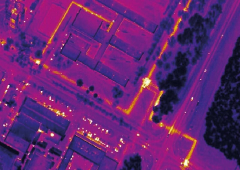
- airborne thermal infrared (IR) imaging, enabling thermal images of the terrain to be obtained and analysed at a spatial resolution of 0.25 m;
- airborne gamma-ray spectrometry (AGS), mapping the distribution of natural (K, U, Th) and artificial (Cs137) radionuclides, gamma radiation dose rate, and, using an original technique, the local radon (Rn222) component;
- airborne gas surveying to determine NO2, SO2, and CH4 concentrations in the air along the path below the flight line;
airborne aerosol surveying to determine the concentrations of up to 60 pollutant chemical elements in atmospheric aerosol.
Each type of investigation can be performed separately; combined into a single system, however, they provide a powerful instrumental means of analysing radiation contamination levels across an area, monitoring gaseous and aerosol air pollution, thermal pollution, etc. All types of aerial survey are licensed by the Ministry of Natural Resources and Roskartografiya. The airborne gamma-ray spectrometric survey method is certified by the IAEA.
The work is performed using a MI-8MTV-1 helicopter specially modified at an aviation enterprise to accommodate the equipment. Flight-line navigation and horizontal georeferencing of the results use the GPS-GLONASS satellite navigation system.
Established in 1984 by decision of the Executive Committee of the Moscow City Council as a specialist enterprise conducting aerial surveys for environmental protection in Moscow, GNPP Aerogeofizika has, for more than 13 years, addressed a broad range of tasks using budget funding and contracts with various organizations and municipal services:
- locating underground district heating networks and assessing their condition, including detecting leaks;
- detecting centres of underground spontaneous combustion in peatlands and household and industrial waste disposal sites;
- identifying polluted areas and sources of unauthorized discharges into urban water bodies;
- assessing the condition of filtration and aeration fields;
- identifying areas of radioactive contamination within Moscow and the entire Moscow region;
- remote environmental monitoring of the near-surface atmosphere;
- geoenvironmental assessment of sites for future development.
The monitoring work is based on airborne thermal IR imaging performed twice a year (in autumn and spring, i.e. at the beginning and end of the heating season). The traditional clients for this work in Moscow are the Fuel and Energy Department of the Moscow Government, the Moscow state enterprise Mosteploenergo, the Heating Networks division of JSC Morsenergo, the municipal enterprise Teploremontnaladka, and Moskompriroda.
It should be noted that airborne IR imaging is the only remote-sensing method that can promptly address the monitoring of heating network condition and update or compile heating network layout maps. In one survey cycle, 70 to 100% of the networks are mapped, depending on survey conditions. As our experience in various Russian cities has shown, this is a highly relevant task, since operating services often have no heating network maps at all, or their maps contain substantial inaccuracies. Following each survey cycle in Moscow, heating network maps are updated; on every occasion this information is of exceptional importance to our clients.
Interpretation results are plotted on a topographic base map to indicate the diagnosed condition of underground heating networks:
- heat losses within prescribed limits;
- increased heat leakage (usually damage to or wetting of thermal insulation);
- pre-failure condition (high heat leakage, most likely associated with the formation of small pinhole leaks);
- failure condition: rupture of a heating pipeline accompanied by outflow of the heat-transfer fluid.
Clients use the resulting materials to prepare and revise annual repair programmes.
Using airborne IR survey data, clients can not only recover their costs quickly but also obtain a profit; the economic benefit increases the sooner the user can assimilate the information and use it to make sound management and technical decisions. For example, acquiring and fully processing airborne thermal IR imagery for 1 km2 costs as much as replacing 10 linear metres of an average trunk heating pipeline. Thus, if analysis of the results reduces the length of heating network requiring replacement by 10 m, the client has already recovered the expenditure. A reduction of 20 m gives a 100% profit. This excludes the benefits of timely identification and repair of failure-prone sections, reduced make-up water requirements, more rational use of persistently insufficient funds, savings on excavation (at last, the location to dig is known…), and simply obtaining and using maps of one's own heating networks.
However, we currently see the greatest difficulties precisely in making the most effective use of thermal aerial survey data. These include inertia among specialists who traditionally distrust remote diagnostics, the continuing low level of computer provision at client enterprises, and an inability to allocate two people and as many computers to work with the results. Finally, there is simply an inability or unwillingness to account for money that, as before, is not one's own. Here is one example. In 1995, Aerogeofizika conducted an airborne IR survey of the entire territory of Moscow. Each client used its share of the results in its own way. A year and a half later, A. M. Goncharov, lead engineer at Heating Networks, performed an analysis: 80% of the failure or pre-failure situations identified in the thermal survey results were confirmed (that is, they eventually developed into full-scale failures). Timely use of these data could have prevented direct losses of 4 billion roubles. Optimizing major repair programmes using IR survey data (together with analysis of the georeferenced asset-record database), through the subsequent improvement in heat supply reliability, is equivalent to increasing repair funding by approximately 30% (for 1996 this would have amounted to about 120 billion roubles). This concerns the assets of just one client. Unfortunately, as far as we know, in this particular case these profits remained on paper.
Another example demonstrates the effectiveness of airborne IR surveying in the same year. An aerial survey of 900 km of heating networks operated by the Moscow state enterprise Mosteploenergo identified 280 sections with heat-transfer fluid leakage, including 163 pinhole leaks. All leaks were eliminated either promptly or through scheduled work. These operations cost 270 million roubles, and the economic benefit amounted to 450 million roubles. This was no coincidence. As a regular client, Mosteploenergo not only routinely makes effective use of airborne IR survey data, but also frequently initiates new levels of processing and specifies requirements for hardware and software. According to chief engineer V. P. Kashcheev, airborne IR surveying, as a remote diagnostic tool for urban heating infrastructure, has now become an integral part of the heating network maintenance process.
The thermal images obtained from the surveys are scaled, i.e. brought into conformity with the specifications of a large-scale topographic base map (1:2000 for the city), allowing them to be used as a raster layer in any geographic information system (GIS). GIS technologies, currently undergoing rapid development, offer extraordinary opportunities for using remote-sensing data at literally every level of executive administration, from the Mayor to a municipal utility dispatcher. Failing to use the available, annually updated digital IR images for land cadastre tasks would simply be inexcusable.
The ability of thermal surveying to detect industrial and municipal wastewater outlets, including those with low discharge rates and weak contrast that are unlikely to be identified visually, allows this method to be regarded as a principal tool for addressing environmental issues in Moscow. It does not even matter whether these discharges are substantially warmer or colder than the waters of the receiving water bodies. This task can, incidentally, be addressed during airborne IR surveys of urban areas, although the best results are naturally obtained through dedicated night surveys with the thermal imaging equipment adjusted exclusively for water. A thermal aerial survey of the Moskva and Yauza rivers, commissioned by Moskompriroda in April 1997, identified a substantial number of industrial and municipal discharges into these rivers, including unauthorized ones.
The Lyublino filtration fields (LPF) have repeatedly been surveyed during airborne IR surveys of Moscow. The results enable confident mapping of areas of active biothermal processes within the LPF, indicating ongoing wastewater inflow into individual field compartments (contrary to official information), and zoning according to the intensity of these processes and soil moisture. Localized water discharges into flow-regulating ponds are also identified. Conducting this work in monitoring mode enables the dynamics of exothermic processes to be tracked and a predictive model of their development to be constructed, and hence the sequence in which the territory can be developed for construction to be determined. Thermal survey data show that the large-scale housing construction initiated in the southwestern LPF, where the most active processes occur, constitutes a gross disregard for requirements concerning the environmental condition of development sites.
The first experimental and methodological airborne gas and aerosol surveys in Moscow were conducted in autumn 1991. An airborne gamma-ray spectrometric survey of the city was also carried out at that time. These were followed by a summer survey in 1992 and a winter survey in 1993, making it possible to speak of seasonal monitoring of the capital's territory. The airborne gamma-ray spectrometric data were transferred to NPO Radon as a basis for its radiation monitoring of the city. The resulting anomalies from point sources (one, in Solntsevo, was approximately 300 mR/h) were localized and identified, and the information was promptly passed to the city's Civil Defence service for decontamination measures. The informative value of the data on radiation conditions across the city should not be underestimated, particularly after the Chernobyl nuclear power plant accident amid growing public radiophobia. This cycle of monitoring investigations demonstrated the potential of the approach and enabled integrated analysis of unique information.
In March 1996, Moskompriroda commissioned an integrated environmental airborne geophysical survey of Moscow using the full suite of methods at a scale of 1:25000. It yielded a broad range of materials (27 maps) characterizing integrated levels of seasonal (spring) pollution of the near-surface atmosphere (gaseous and aerosol components) and the surface (gamma-ray spectrometric data).
Of the gaseous components investigated, nitrogen dioxide was the most prominent in the city's atmosphere, with mean concentrations in different districts ranging from 70 to 130 ppb (1.5–3 times the maximum permissible concentration). Elevated atmospheric NO2 concentrations correlate spatially with operating industrial enterprises, including combined heat and power plants, district heating stations, and others. Vehicle exhaust is also a major source of nitrogen dioxide; consequently, areas with the highest NO2 values tend to occur at major road intersections.
The resulting data constitute factual material that can be used by a wide range of users as an element of environmental monitoring in Moscow. They can support an integrated assessment of the near-surface atmospheric layer and zoning according to pollution severity and the composition of pollutant factors. In addition, mass reproduction of the materials as a map atlas or on CD-ROM may have value in its own right, including commercial value.
Essentially an element of monitoring Moscow's environmental condition, this work is intended to continue until a complete picture of seasonal pollution levels across the city is established. Obtaining equivalent materials for autumn, winter, and summer, together with data from ground observation stations, will enable predictive assessment of air conditions in the capital.
Ultimately, remote environmental monitoring aims to obtain integrated information for preparing and adopting substantiated management decisions intended to manage the population's quality of life. The analysis should incorporate diverse environmental data, a range of sociodemographic characteristics of the population, information on the locations and technological cycles of industrial enterprises, and similar materials. Clearly, the dimensionality of the analysed dataset may reach tens or even the low hundreds of parameters. Meaningful analysis of data of this dimensionality is impossible without specialized methods of integrated mathematical processing. GNPP Aerogeofizika has the methodology and experience to conduct targeted integrated data processing alongside remote environmental aerial surveys to address these tasks. The optimal integrated solution to the entire range of problems and tasks arising from survey acquisition through analysis should be the creation of a dedicated city GIS, Environment–Health, with built-in multidimensional data-processing functions, including ground survey data and urban statistical databases. Incorporating remote environmental monitoring materials into any GIS presents no difficulty, since all information is digital and precisely georeferenced.
A shortage of funds for research programmes in environmental protection and municipal utilities is today's reality and, most likely, tomorrow's as well. This inevitably demands the selection of the most effective and economical methods and technologies. It is therefore appropriate to recall that highly informative remote airborne geophysical surveys provide, above all, an integrated solution together with savings for the municipal budget.
When you see a helicopter in Moscow's sky, you can be sure that your money is not being thrown to the wind: it is working for the city's economy and its future, returning as savings and greater efficiency in municipal and environmental programmes. If you have not been left without heating in winter, have never had to cross streams of hot water, and have not found a network of trenches in your courtyard in summer, you should know that the remote monitoring system has done its job. To a high standard. Comprehensively. And on time.