

Home · Resources · Publications
Equipment for Remote Sensing
| Author(s): Babayants P.S., Kontarovich O.R. |
The development of airborne geophysical surveys as part of geological mapping, mineral exploration, environmental investigations and many other applications depends primarily on continual improvements in equipment, software and survey methodology. The advanced technological level of airborne geophysics worldwide and its growing popularity in the mining, oil and gas industries, environmental investigations and remote monitoring of engineering structures are largely attributable to continual equipment improvements aimed at increasing the quality and detail of observations while reducing survey costs.
In addition to the technological renewal common to all industries, airborne geophysics has particular characteristics: the use of aircraft influences the design concepts of airborne geophysical instrument developers. Aviation has traditionally adopted the most advanced technologies, and this tradition influences airborne geophysical instrumentation. Early applications of satellite navigation systems, laser radio altimeters, industrial personal computers and similar equipment are illustrative: all these new designs became components of airborne geophysical systems as soon as they reached the market.
One of the most important strategic principles guiding the operations and development of GNPP Aerogeofizika is the use of the most advanced available equipment and technologies for airborne surveys, and their modernization with the involvement of leading specialists from the company or elsewhere in the country. This approach was already established during the Soviet period. Even after centralized funding for industry-wide equipment modernization ceased, Aerogeofizika continued to spend most of its profits on developing, acquiring and introducing modern equipment and technologies.
Instrumentation for Remote Sensing Methods
Aeromagnetometry is a traditional airborne geophysical method used to address a very broad range of geological and other problems. Over the past decade, extensive use of quantum sensors, mainly cesium sensors, has substantially increased instrument sensitivity and measurement frequency. A sensitivity of 0.001 nT at 10 measurements per second is now effectively the worldwide industry standard.
In the 1970s, GNPP Aerogeofizika used domestically manufactured BTM and KAM-28 quantum magnetometers and YaMB-3 proton magnetometers, as well as G-801/3B proton magnetometers from Geometrics and proton magnetometers from Zander, providing a sensitivity of 1 nT at 1 measurement per second. Both rigidly mounted magnetic sensors with analog compensators and sensors in towed birds were used.
In 1994, GNPP Aerogeofizika became the first organization in our country to acquire and use in production surveys the latest Scintrex airborne magnetometer with a CS-2 cesium sensor, a resolution of 0.001 nT and a measurement frequency of 10 readings per second. Aerogeofizika subsequently funded development of its own airborne magnetometers of this class, named AEROMAG. These are now used at our company, and two units have also been supplied to Almazy Rossii–Sakha, where they are successfully used for kimberlite exploration.
In 1996, GNPP Aerogeofizika carried out a series of experimental and methodological flights in an L-410 aircraft for hydrocarbon exploration surveys, using a rigidly mounted magnetometer sensor with a Canadian fluxgate magnetic-deviation compensator. Original software developed at our company to post-process compensator data reduced maneuver-related magnetic deviation to hundredths of a nanotesla. Magnetic cleaning of the aircraft, combined with this digital deviation compensator, enables aeromagnetic oil and gas exploration surveys to meet the most stringent requirements of leading domestic and Western oil companies.
In addition to airborne instrumentation, GNPP Aerogeofizika has developed and operates a magnetic-variation base station integrated with a GPS receiver. Its high operational performance meets and even exceeds the current international level of comparable instruments.
Airborne gamma-ray spectrometry, after extensive use domestically and abroad to explore for radioactive mineral deposits that produce sufficiently distinct gamma-field anomalies, is now focused on highly reliable mapping of radioelement distributions at average crustal abundance levels to address a wide range of geological and environmental problems.
Conducting airborne gamma-ray spectrometric surveys since 1972, GNPP Aerogeofizika, in cooperation with the All-Union Institute of Mineral Raw Materials, developed a series of AGS-4k / AGS-10k airborne gamma-ray spectrometers. These used 128- and 256-channel spectrum analyzers. The detectors consisted of several cylindrical NaI(Tl) crystals with a total volume of up to 15 liters and an energy resolution of 14–15% at the 0.662 MeV line. Gamma-ray intensities in five differential windows, altimeter data and other auxiliary information were recorded on punched tape. The spectrometer also included a special unit that applied real-time height corrections and, with straightforward console programming, performed any interpretation operations (calculation of natural radioelement concentration ratios, the dominant radioelement and radiochemical specialization), outputting the results to chart paper. At the time, this was necessary for rapid decisions on detailed investigation of promising anomalies and marking their centers on the ground with dropped markers. The Exploranium Digrs-3001 airborne gamma-ray spectrometer was also used from 1972, although it was inferior to the above domestic spectrometers in several parameters.
In 1980, 512-channel Spectra-2 airborne gamma-ray spectrometers from Exploranium were purchased as part of a McPhar system. They used prismatic NaI(Tl) scintillation detectors with a volume of up to 48 L and an energy resolution of 9% at the 0.662 MeV line. Extensive expertise in modern electronic components and the high qualifications of the company’s developers and programmers enabled substantial modernization and improvements in operational performance. Based on the excellent Polyscin crystals, GNPP Aerogeofizika now has three modern gamma-ray spectrometers which, unlike the originally purchased instruments, feature new electronics with modern ADCs, a 4096-channel spectrum analyzer and a Pentium PC. The data acquisition and recording system has been fundamentally redesigned.
A unique computer-based method has been developed to correct the “uranium” channel for airborne radon-222, a radioactive isotope of a noble gas. This method requires no so-called atmospheric detector, yet unequivocally improves uranium data quality and enables areas of elevated radon concentrations to be identified close to their emanation sources. Its practical application in airborne gamma-ray spectrometric surveys in Tatarstan, Tula and Ryazan regions, and parts of Moscow Region, made it possible to identify open (permeable) faults among all the mapped faults.
Airborne electromagnetic surveying, another traditional airborne geophysical method, was previously used primarily to identify and map rocks and ores with anomalous electronic conductivity. Improvements in measurement and interpretation capabilities have expanded its application to a broad range of practical tasks: lithological and petrographic mapping in plan and section for exploration and geological surveys; mapping water saturation in the subsurface; and identifying zones of secondary rock alteration as indicators of ore formation or secondary mineralization associated with hydrocarbon migration from accumulations.
For many years, GNPP Aerogeofizika successfully developed the DIP-A fixed-wing airborne electromagnetic system (Airborne Dipole Inductive Profiling). This work was directed by, and involved the direct participation of, staff from the Physicomechanical Institute of the Academy of Sciences of the Ukrainian SSR and TsNIGRI. Dipole inductive profiling with a harmonic source signal and a nonlocal transmitter–receiver separation provided secondary-field information by measuring a semiaxis of the magnetic-field polarization ellipse using an algorithm proposed by B. S. Svetov. The first DIP-A instruments could measure at only one fixed frequency at a time. Obtaining information at higher or lower frequencies required retuning the transmitter and repeating the flights. This equipment successfully identified highly conductive ore deposits in exploration for Norilsk-type copper–nickel deposits and gold deposits in black-shale sequences, and mapped the contact between bituminous and reef limestones in bauxite exploration in the Urals. The Canadian McPhar F-400 airborne electromagnetic system had also previously been used for these purposes.
In 1996, a new three-frequency DIP instrument, developed to our company’s specifications and funded by the company, entered production use. This modern, fully digital system represents another step in the evolution of airborne electromagnetic systems. At present, the new DIP has no equivalent in the CIS. It uses simultaneously transmitted harmonic fields at 273, 1092 and 4368 Hz, with vertical magnetic dipole moments of 8000, 4000 and 3000 A m2, respectively. Ratios of the projections of the polarization-ellipse semiaxes onto the observation plane are measured. High accuracy is achieved through an invariant measurement scheme, automated calibration, eddy-current compensation and a towed-bird position-tracking system.
The next, still more advanced model is planned for 1998. Meanwhile, GNPP Aerogeofizika continues to improve its own specialized software for computer processing and interpretation of airborne electromagnetic data.
Airborne thermal infrared (IR) imaging, designed to study the thermal field of the Earth’s surface remotely, plays an important role in environmental and geological investigations and in remote assessment of engineering structures and natural features. Long used for military purposes, it began to be successfully applied in the late 1970s, initially in experimental work and later in production surveys, to address a wide range of practical tasks. Since this technology was developed and successfully introduced into production at GNPP Aerogeofizika, where its most active development continues, it is covered in a separate article in this journal, including instrumentation developments.
Overall, this field has incorporated so many scientific discoveries and new technical solutions that its potential applications have not yet been fully appreciated. During the principal development work, several ancillary technical solutions were also developed that brought tangible economic benefits to related fields: a universal data acquisition and recording system, a new navigation processor with active flight-line interception, software for post-processing digital-compensator data, and others.
The initial civilian use of airborne thermal IR imaging was associated with attempts to solve geological problems in the 1960s. Satisfactory results were obtained in studies of active volcanic and hydrothermal features, that is, in areas with very strong thermal-field contrasts. The limited metrological capabilities of the instruments and survey methods then available prevented application to areas and geological problems with weaker, more typical thermal-field contrasts. Improvements to the equipment and methodology achieved at GNPP Aerogeofizika (ground optical resolution of 0.1–0.2 m and sensitivity of 0.1°C) suggest that highly effective geological applications in areas with ordinary thermal-field contrasts can be expected in the near future. It can reasonably be anticipated that airborne IR imaging will soon join the traditional suite of airborne geophysical methods widely used in geology as a highly informative method.
Airborne aerosol surveys collect atmospheric aerosol samples on special filters using a compact filtration unit. These ultraclean filters are disks 40 mm in diameter and capture at least 95% of atmospheric aerosols at sampling airflow velocities of 0.5–1.5 m/s. The sampling procedure is designed so that one filter represents an area cell, for example 1×1 or 2×2 km. The chemical composition of the samples is determined by coupled-plasma atomic emission spectroscopy, enabling simultaneous measurement of numerous chemical elements over a wide concentration range with sufficiently high accuracy and detection limits of 0.1 to 0.002 μg/filter.
Laboratory results in μg/filter are converted to volumetric concentrations in μg/m3, accounting for the volume of air passed through the filter and background metal concentrations. Aerosol survey results are used to map the distributions of the corresponding elements in atmospheric aerosols.
Airborne gas surveys use onboard correlation optical gas analyzers to determine nitrogen dioxide (NO2) and sulfur dioxide (SO2) concentrations in the free atmosphere along the optical path below flight altitude in real time, together with an optical infrared laser absorption analyzer for methane (CH4). The remote optical method for determining gaseous impurity concentrations is based on analysis of gas absorption spectra.
Navigation
Previously, airborne geophysical measurements were positioned by photographing reference landmarks and transferring them from aerial photographs to topographic maps. Aircraft positioning accuracy, especially between landmarks, was no better than ±100–200 m. Adherence to prescribed flight lines depended heavily on the navigator’s skill, and the requirements for surveys at 1:25,000 scale were rarely achieved.
In 1979, we purchased navigation equipment from the Canadian company McPhar that provided active guidance of aircraft and helicopters and substantially improved the accuracy and continuity of positioning airborne geophysical measurements. For the first time in the former USSR, GNPP Aerogeofizika used onboard heading-navigation systems with Doppler velocity measurement systems (DISS) and gyroscopic systems. These systems determined coordinates every second with an accuracy of ±40–60 m and more than satisfied flight-line adherence requirements for surveys at 1:25,000 scale.
GNPP Aerogeofizika subsequently became the first in the country to use long-range radio navigation systems (RSDN) and domestically manufactured multichannel receiver-indicators for the GLONASS satellite navigation system (A-735). Finally, GPS NAVSTAR satellite receivers were also first installed on aircraft and helicopters at GNPP Aerogeofizika.
In 1996, GNPP Aerogeofizika became the first organization worldwide to use ASHTECH’s latest product, the 24-channel GG-24 receiver, which uses signals from both GLONASS and GPS NAVSTAR. Only after we presented our results at the international exhibition and conference in Denver in November 1996 did leading foreign airborne geophysical equipment manufacturers promptly add GG-24-based navigation systems to their product catalogs. Navigation systems using GPS and GLONASS satellites provide current coordinates at frequencies of up to 5 Hz with an accuracy of ±10 m or better.
Onboard data acquisition and recording systems based on modern industrial computers, with unique onboard software, ensure highly efficient use of flight time and high-quality survey data.
Equipment for Data Processing and Interpretation
A large inventory of modern computers and peripheral equipment enables rapid, high-quality routine field and final processing of acquired geophysical data. It includes the latest-generation PC-compatible personal computers, an ALPHA workstation, a range of color and monochrome wide-format plotters and printers, scanners and other equipment.
High-quality software, developed both in-house and by leading international companies (ARC/INFO, CorelDRAW, GEOSOFT and many others), produces deliverables meeting the most stringent requirements of domestic and Western mining and oil companies, in accordance with the best current Russian and international standards.
Equipment Integration and Aircraft Platforms
Thus, GNPP Aerogeofizika currently has the most advanced range of equipment in the CIS and, in some categories, worldwide. It includes the following:
- A quantum magnetometer with a sensitivity of 0.001 nT at a measurement frequency of 10 Hz.
- A 1024-channel gamma-ray spectrometer with prismatic NaI(Tl) scintillation detectors of up to 48 L volume, an energy resolution of 9% at the 0.662 MeV line, and computer-based correction of the “uranium” channel for airborne radon.
- An electromagnetic survey channel implementing the DIP-A method, using simultaneously transmitted harmonic fields at 273, 1092 and 4368 Hz, with vertical magnetic dipole moments of 8000, 4000 and 3000 A m2, respectively.
- An airborne thermal infrared imaging hardware and software system operating in four spectral channels with high spatial resolution and recording data to the onboard computer’s hard disk, providing a ground optical resolution of 0.1–0.2 m at a sensitivity of 0.1°C.
- A path-integrated atmospheric SO2 and NO2 concentration meter based on an optical spectral correlator.
- An atmospheric aerosol particle sampler operating on the inertial aspiration principle.
- Navigation systems using GPS and GLONASS satellites, providing current coordinates at frequencies of up to 5 Hz with an accuracy of ±10 m or better.
Previously, the integration of this equipment for surveys was largely governed by whether all the instruments could be accommodated on a single aircraft. Today, developing targeted geological investigation technologies requires a specific suite of airborne geophysical methods, aircraft platforms and geophysical sensor mounting configurations to be defined for each type and stage of work. Addressing these tasks naturally led to modular integrated airborne geophysical systems, in which different measurement units share a unified computer-based system for controlling data acquisition, processing and storage.
Modular airborne geophysical systems are installed on different aircraft depending on survey scale, physical geography and the type of work.
The An-26 aircraft is used for regional surveys, such as airborne gamma-ray spectrometric surveys in Western and Eastern Siberia and geotraverses, or for exploration over large areas at scales of 1:25,000 and smaller. It is equipped with an airborne gamma-ray spectrometer and a magnetometer whose sensor is housed in a towed bird. Achievable productivity is 35,000 line-km per month. The lighter L-410 aircraft is used for similar tasks. Its magnetic sensor is rigidly mounted on the aircraft stinger, with automatic digital compensators used to eliminate magnetic-deviation interference. Monthly productivity can reach 20,000–25,000 line-km.
Three-method airborne geophysical surveying (magnetometry, gamma-ray spectrometry and electromagnetic surveying) is implemented on two aircraft types: the highly economical An-2 for flat terrain and the Mi-8MTV helicopter for mountainous terrain. Survey scales are 1:25,000 and smaller, with monthly productivity of 10,000–12,000 line-km. Detailed aeromagnetic surveys at scales of 1:5,000–1:10,000 over local areas, with flight-line lengths of 3–10 km, use the light, economical Ka-26 helicopter. The magnetic sensor is placed in a deployable bird; because the helicopter’s magnetic mass is very small, the suspension cable is only 10 m long. This enables high-accuracy aeromagnetic observations at extremely low altitudes. Productivity is 7,000–9,000 line-km per month.
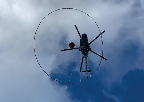
One of the latest Canadian developments in integrated helicopter electromagnetic systems, Geotech’s four-frequency HUMMINGBIRD system, entered service at GNPP Aerogeofizika in 1996. This was the first system of its kind to enter the CIS in the history of domestic airborne geophysics. Extremely popular in the West, such systems combine multifrequency electromagnetic surveying with high-accuracy magnetometry, enabling highly effective mineral exploration and mapping in remote mountainous regions. At our company, HUMMINGBIRD has been successfully integrated with a high-resolution gamma-ray spectrometer on a Mi-8 helicopter, further improving exploration and survey effectiveness.
Environmental surveys of cities use a Mi-8 or Mi-8MTV helicopter carrying a gamma-ray spectrometer, thermal imager, atmospheric aerosol collector and cable-based gas detector simultaneously. With their high payload capacity and ample power, these helicopters meet the stringent safety requirements for flights over urban agglomerations such as Moscow, Nizhny Novgorod and Tula.
GNPP Aerogeofizika’s near-term plans include creating a multifunctional airborne geophysical laboratory on an L-410 or An-26 aircraft, or others of the same classes, capable of performing virtually all survey types currently available: two electromagnetic channels in DIP and AMPP configurations; magnetometry with a detector in a deployable bird and/or rigidly mounted; gamma-ray spectrometry; infrared imaging; and gravimetry.
In conclusion, continuous improvement of airborne geophysical technology is an essential component of GNPP Aerogeofizika’s internal strategy. It accounts for the company’s past and present success and provides sound grounds for confidence in its future prospects.